Wild, Wild Weather: How Pressure Gradients Cause Winter Wildfires
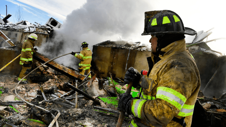
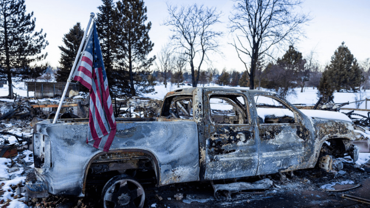
“Wildfire season” has become a common term to describe widespread summertime fires in dry areas of the Pacific Northwest, California, the Colorado Rockies and beyond. But this seasonality may be a thing of the past. Wildfire season has become longer than ever; 2021’s extended into the end of December. The Marshall Fire that affected the greater Denver area are currently bringing into question the idea of a specific season when wildfires occur. Wildfires can happen even in winter — and, as we saw with the Marshall Fire, while it’s snowing.
The Governor of Colorado, Jared Polis, addressed the matter, saying, “this is the kind of fire you can’t fight off. This fire is not so much a question of resources… This fire is frankly a force of nature.” The fire burned 9.4 square miles of land and destroyed close to 1,100 homes. It will take an investigation to know the fire’s cause, but the culprit for its reach? The fires probably would not have been as bad if not for the wind.
Wind may be invisible, but meteorologists have been studying it for ages and understand that it’s the result of something called pressure gradients. Let’s take a look at pressure gradients, the forces that they can create and what we can learn from them.
Changing Air Pressure and the Causes of Wind
Wind is the natural movement of gasses, like air. It isn’t visible unless there’s a gas that’s different from oxygen in an area. You can see objects get moved by the wind, though, which is like seeing the natural phenomenon in action. Wind can affect the amount of precipitation in a storm, and it can also spread a fire.
What happens when wind forms? You may remember learning that windy weather often occurs when atmospheric gases move from lower-temperature areas to higher ones and vice versa. But what happens atmospherically to make this occur? Think of changing temperature as a domino falling onto other dominoes in a set. When air suddenly gets colder or warmer, the atmosphere around it changes.
When this pressure changes across a given distance or area, it’s called a pressure gradient. Strong reactions can often occur due to a gradient in pressure. This is called a pressure gradient force. This most commonly occurs when an area where high pressure shifts into lower pressure.
The Power of Pressure Gradient Forces
So, there are areas with low pressure and high pressure in our atmosphere. Clear skies, dry weather and higher temperatures during the day are associated with high pressure. Rain, cloudiness and stormy weather most often occur along with low pressure in the atmosphere. Depending on where you live and what season it is, low pressure can also mean snow instead of rain. High and low pressure can both happen year-round.
Let’s apply this to Colorado’s Marshall Fire: The Denver area, like much of the West Coast, has been experiencing drought conditions for years. Based on this, it would make sense that the large, lush trees that are emblematic of the state had become drier than they have been in past years. Despite any moisture the snow provided, the drought conditions became severe enough that the wildfire still happened.
According to the National Weather Service, wind gusts surpassed 115 miles per hour in some areas of the state. More than 30 gusts of wind that exceeded 50 miles per hour were recorded on December 30, 2021. To call it a “blustery day” would be a bit of an understatement.
The wind’s strength can be accredited to the pressure gradient brought on by the winter storm. Although the snow hadn’t started when the fire was believed to have ignited at 11 a.m. on December 30, the snowfall was still noteworthy. The Denver Gazette reported up to 16 inches of snow in some towns by midday on December 31, 2021.
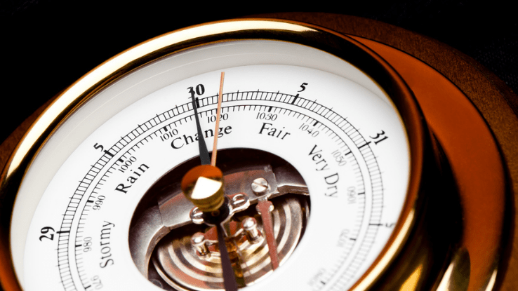
Looking at a barometer, which measures air pressure, can help explain why strong winds formed and later caused the fire to spread so quickly. A “normal” barometer reading will be about 30.00 inHg. Let’s look at the month of December for Thornton, CO, which is about 20 minutes north of Denver. Its highest pressure occurred on December 18 with a reading of 30.34 inHg. By December 30, the reading dropped to 29.65 inHg. Pressure continued to drop with a 29.59 barometric reading on December 31. These changes created quite a large pressure gradient over the area.
This type of shift in pressure is what causes the strong, forceful winds of pressure gradient forces. Thankfully, we have technology that can help us predict when they can occur. This is why meteorologists work around the clock: so people can stay informed about drastic weather changes and take the necessary steps to protect themselves.
How to Learn More About Pressure Gradient Forces
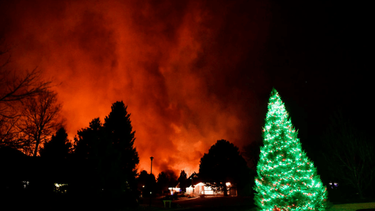
It’s okay to acknowledge how surreal it is to see a wildfire rage on while heavy snow falls. It looks like something that shouldn’t be able to happen, but it did. After learning about pressure gradient forces, you may be feeling uneasy about weather disasters, and that’s okay.
After reading this, you know that a phenomenon like the Marshall Fire was made possible due to pressure gradient forces caused by low air pressure in the atmosphere. Drought-fueled wildfire anxiety is also very real. But learning more about fire safety and weather effects can help you feel better prepared to navigate this kind of event.
You can get started by learning how to put together an emergency plan for disasters. Weather equipment like thermometers, barometers and windspeed-measuring devices called anemometers can help you track air pressure and other aspects of the weather in real time and see what’s typical for your area. The Farmer’s Almanac is also a great resource that can help you learn more about weather. You could even become a local weather watcher, and help aid your community. We can’t control the weather, but understanding what it can do can make a big difference our response if disaster does strike.


